A participatory guide for strengthening flood governance in B.C.
by Thy Huynh and Vanessa Lueck
Flooding caused by climate change is a growing challenge for communities in British Columbia—but what if the key to building a better, more resilient future lies in understanding the past?
There tends to be a gap between planned flood governance and the lived experiences and realities communities face during floods. By mapping out key events —such as past floods, policy changes, and community actions— in parallel with lived experiences, community leaders and professionals can learn from past experiences to improve future responses.
Timeline mapping is a powerful tool that can help communities trace how past decisions and challenges may (or may not) have evolved over time. Imagine it as layering the pages of a history book—each event is a chapter, and as you flip through, you start to see recurring themes, pivotal turning points, and the long-term effects of key choices. By revealing patterns and key events (ex., government, time, location), timeline mapping helps capture multiple perspectives on the processes that have shaped today’s adaptation efforts.
Timeline mapping is most effective when it brings together people from all parts of the community or region—such as Indigenous leaders, business owners, environmental advocates, Elders, and young people. Each group has unique experiences with flooding and can point out key moments that have shaped local flood management. By sharing and then collectively ranking the impact of these events, the group builds a clearer picture of how past decisions affected today’s challenges.

Creating an inclusive space where everyone feels comfortable sharing their insights – whether in person, online, or through a mix of both – is key to successful timeline mapping. When participants feel comfortable sharing their perspectives, the group can uncover past and potentially unintended consequences, and initiate collaboration through shared experiences. For example, participants might realize that a flood control measure in one area worsened flooding downstream, which could prompt better collaboration across regions. These reflections highlight the value of bringing diverse voices together to address complex challenges such as climate change.
The PICS-funded Living With Water project recently released its Flood Governance Mapping Report, which summarizes workshops the project team conducted in 2023 and 2024. Although this report focuses on flood governance, timeline mapping can also be used to understand and plan for other hazards and community needs.

How to host your own timeline mapping workshop
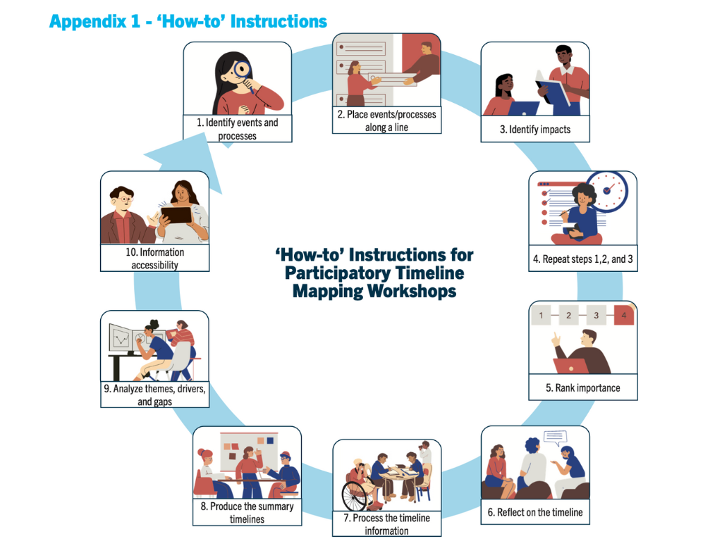
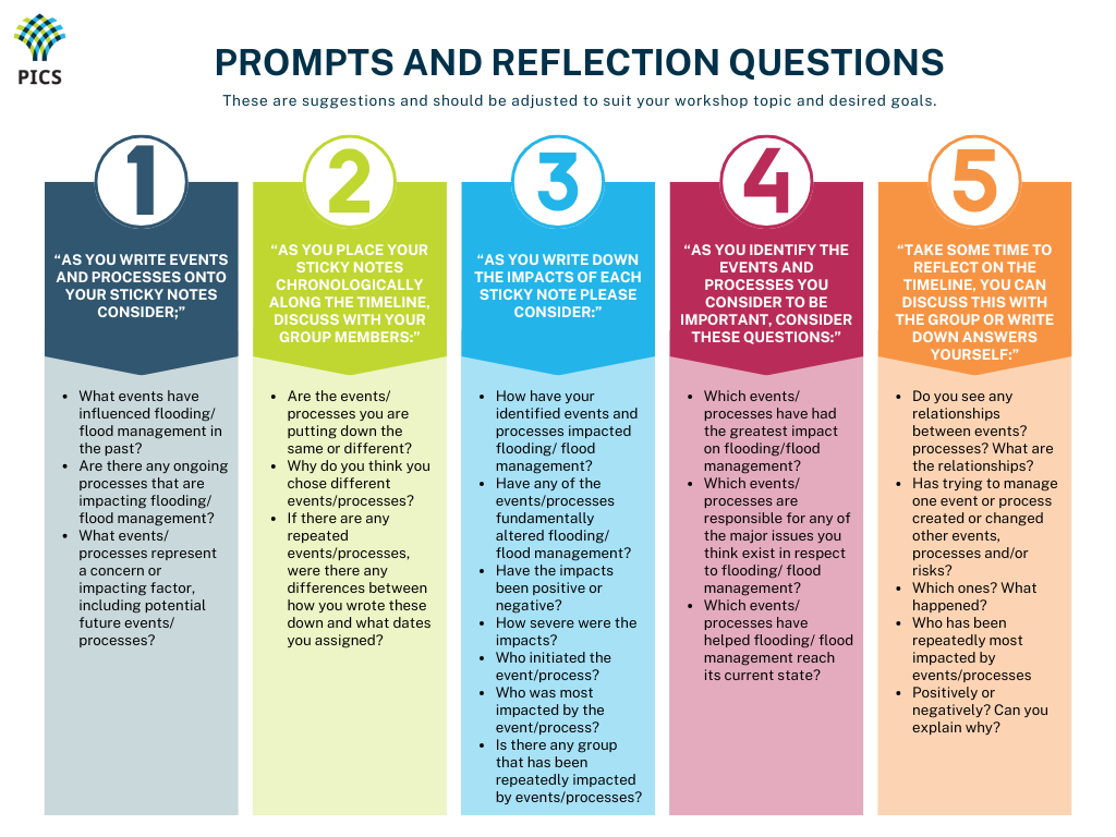
There is no one-size-fits-all way to run a timeline mapping workshop. Below is the approach the Living With Water team used (Figure 1), but facilitators are encouraged to tailor their workshops to align with the specific values and goals of their group. To demonstrate how workshops can be tailored based on specific goals and needs, Figure 2 outlines example prompts and reflection questions that correspond with each step of the timeline mapping process. Timeline maps can serve different purposes across different contexts, so flexibility is key.
Flood Governance Mapping Report.
For further inspiration and guidance, Appendix 3 in the Flood Governance Mapping Report includes examples of other timeline mapping workshops found within academic literature.
Strengthening flood resilience
Living With Water will offer templates for various hazard timeline maps as a “starting point” for community leaders and professionals. However, folks engaging with timeline mapping will need to centre place-based context to the exercise to ensure it addresses specific issues and local experiences/knowledges.
By learning from the past, communities and practitioners can make better decisions for the future.
The full Living With Water report expands on timeline mapping for flood governance.
Thy Huynh is a research assistant with the Living With Water project, and a recent graduate from the master’s program in the School of Environment, Resources and Sustainability at the University of Waterloo.
Dr. Vanessa Lueck is researcher-in-residence, coastal adaptation, with the Pacific Institute for Climate Solutions, and is a principal investigator with the Living With Water project.