First-of-its-kind research in Canada’s Columbia Basin shows that the glaciers that supply the Columbia River with meltwater are 38 per cent thicker than previously thought, but researchers say this won’t offer much of a lifeline against melt due to climate change.
The Columbia River basin produces over 40 per cent of hydroelectricity in the United States, with the Canadian portion of the upper basin providing 30 to 40 per cent of total runoff, predominately from snowmelt but also ice. The river is a vital downstream freshwater source and habitat for aquatic ecosystems.
The research, led by University of Northern British Columbia scientists and supported by the University of Victoria-hosted and -led Pacific Institute for Climate Solutions (PICS), was published this autumn in the Journal of Glaciology.
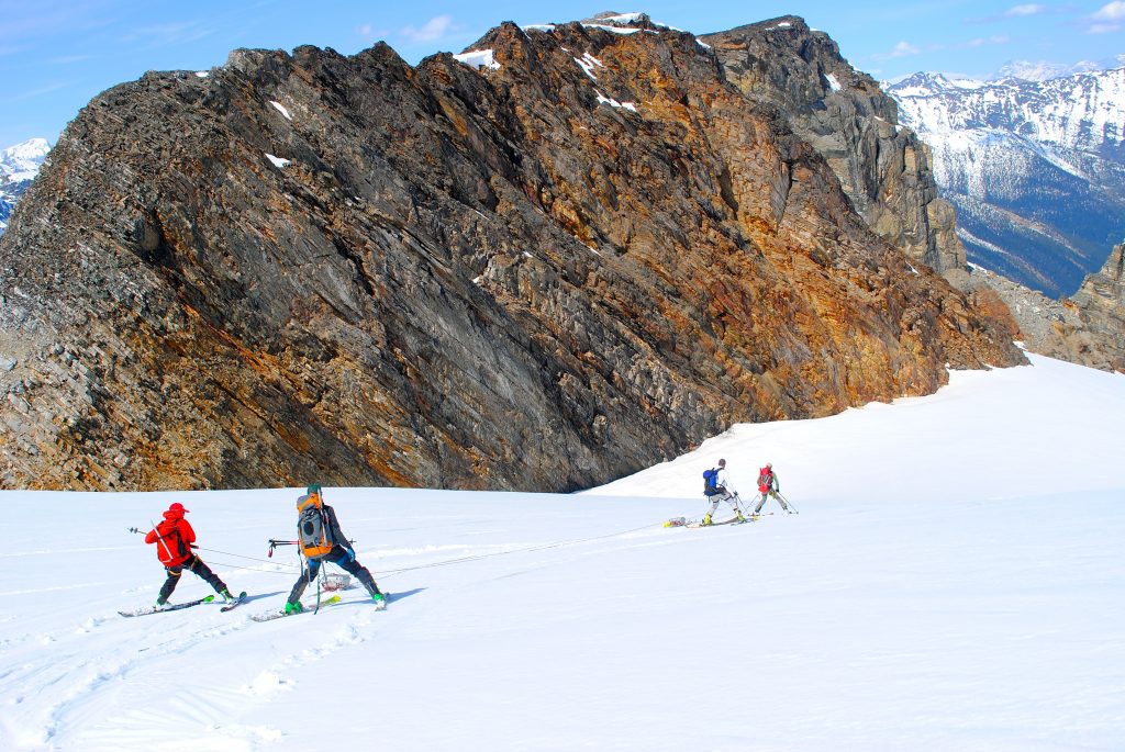
The researchers calculated the glaciers’ true size by using ice-penetrating radar, towed by skiers, to measure ice thickness over five glaciers in B.C.’s Columbia Mountains from 2015 to 2018. They then combined that data with two previous surveys for two glaciers in the Rocky Mountains.
After analyzing more than 34,000 data-points measured over 182 kilometres, researchers found that glacier thickness is, on average, 38 per cent thicker than previous computer model estimates. They also calculated that the ice volume for the Upper Columbia Basin is approximately 122 cubic kilometres, equivalent to roughly five times the volume of Okanagan Lake—23 per cent greater than the range of previous estimates.
Lead author Ben Pelto says some glacial ice at high elevations may exist years or even a couple of decades longer than anticipated, but unfortunately their large size won’t offer a lifeline against climate change.
“At current rates of glacier mass loss for this region, our study shows that glaciers will disappear from the basin in about 65 to 80 years. This aligns with evidence from separate studies that found that glaciers in the basin will lose 60 to 100 per cent of their ice by 2100, depending on greenhouse gas emissions,” he says. “Disappearance of these glaciers will negatively affect the basin’s surface hydrology, freshwater availability and aquatic ecosystems, potentially affecting fish stocks and habitat.”
Pelto says in fact, peak water flow from these shrinking glaciers may have already occurred, as found by an earlier study, because as glaciers retreat they lose their low-elevation ice first, shrinking the glaciers.
“Essentially, glaciers act as on-demand water towers, supplementing streams with cool, plentiful water during late summer when runoff from snowmelt has passed. For example, the Mica Basin in the Northeast Columbia Basin contributes up to a third of streamflow from glacier ice melt during August and September,” he says. “Ice area loss is reducing the capacity for glaciers to act in this manner.”
It is the high volume of local data gathered for this study that has enabled a more in-depth analysis of the Columbia Basin than previous regional and global estimates could, making it more akin to research typically carried out in the European Alps. Glacier observations in western Canada are sparse in comparison.
Pelto recommends ice thickness measurements should be made for other glaciers in province, such as B.C.’s Coast Mountains, in order to gain a sharper focus on glacier retreat and on streamflow projections for regional and global purposes, including hydropower planning and environmental studies.
The report is called Bias-corrected estimates of glacier thickness in the Columbia River Basin, Canada. Five of the seven study Columbia Basin glaciers lie within the Columbia Mountains (the Conrad, Kokanee, Zillmer, Illecillewaet, and Nordic glaciers), while the West Washmawapta and Haig glaciers lie within the Rocky Mountains.
PICS is hosted and led by UVic, in collaboration with the University of British Columbia, Simon Fraser University, and the University of Northern British Columbia.
This research was supported by PICS, the Columbia Basin Trust, Natural Sciences and Engineering Research Council of Canada, Tula Foundation, BC Hydro, and other agencies.
A media kit containing high-resolution photos and other digital assets are available at this link on Flickr.


